Navigation programs for Android tablet. Description for GPS navigator without internet via satellite maps. The best GPS navigation programs
A smartphone can replace a car navigator if you install the right application
Standard smartphone navigators are tied to the Internet and may not work if there is no connection. In addition, a constant Internet connection quickly drains the battery and consumes traffic. This is unacceptable if you are traveling, where the issue of charging your phone is very pressing. What can we say about situations when you find yourself in places where there is no cellular network and, accordingly, no World Wide Web.
Offline maps will help save traffic and phone charge
It was for such circumstances that developers came up with offline navigation programs. They will help you out anywhere and at any time, and will give you the opportunity to find your bearings and choose the right direction.
How do navigation apps for Android work without the Internet and where to get them?
Modern Android devices are equipped with GPS. These are sensors that communicate with the satellite. Contact with the satellite system allows you to determine your location, regardless of the presence or absence of cellular coverage. It works on the same principle. To use this system, you just need to install a paid or free navigation program for Android, which can work without the Internet.
This can be done in a few minutes, but in this case you cannot do without the World Wide Web. You'll have to find and download the application.
Online utilities require traffic, so it only makes sense to install them if you have an unlimited connection. And offline systems save maps in the phone's memory. Available free navigator programs for Android can work without the Internet, but will require a large amount of free space in the device’s memory. This is their main drawback, but here, as they say, there is no choice. How to download and configure the navigator application:
- connect to the Internet and create a Google account, following the system instructions, log in;
- Log in to the Play Market; by default, every smartphone or tablet has a login icon;
- type in the market search bar the name of one of the utilities that we will discuss below;
- when the program is found, select download and once downloaded on your device, run it.
On what basis do you choose the best navigator for Android without the Internet?
Program developers are constantly improving their creations. If quite recently navigators could only plot a route to the desired point and provide the opportunity to view maps, now they offer information about traffic jams along the route, congestion due to accidents, attractions, gas stations, cafes and much more. In addition to the above, programs can warn you about video cameras and traffic police posts installed along the way.

Which is better to choose a navigator on a phone without the Internet? First, decide for what purposes you will use the utility. If you plan to travel around the country, it is better to download adapted applications with detailed maps; around the world - pay attention to specialized programs for Europe and Asia.
For example, travelers around Russia will appreciate Navitel - it is a paid program with a trial period of 30 days with the most detailed maps. For tourists in Western Europe, MAPS.ME with its detailed maps and detailed information will be indispensable. Citizens will enjoy the Yandex application with the ability to search for shortcuts, and Google Maps will provide the opportunity for virtual travel to all corners of the planet. We invite you to take a closer look at these and other applications and choose the one that suits you best.
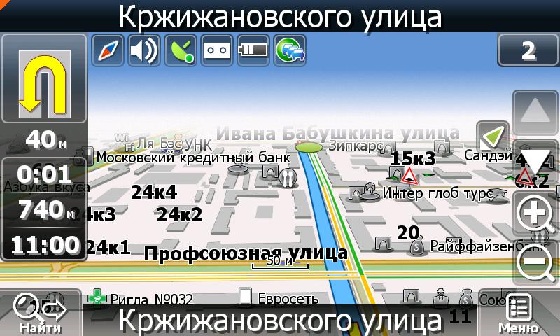
It is rightfully considered the most popular navigation program for tablets and smartphones. Wide functionality, a clear Russified interface, no advertising and free service - this is what captivates millions of users. Yandex will not only help you plan your route, but will also provide information on all important marks along the way: from traffic jams to places of interest.

Vector maps weigh relatively little. In the absence of contact with the network, you can use them confidently. But you won’t be able to build a route without connecting to the network; you can use maps in the same way as you use a regular paper atlas.
FOR YOUR INFORMATION!

How to work with Yandex navigator without the Internet:
A navigator that works without the Internet - the Waze application
Another powerful GPS navigator for Android devices that works without the Internet can be downloaded for free from the Play Market - this is Waze. A social application in which you can not only create routes and navigate the roads, but also communicate with other drivers, receiving useful information from them. It should be noted that it has a simple and clear Russified interface with extensive settings.
Each Waze user can choose a theme, map display mode, radius for receiving information about events, and much more.
The only drawback of Waze is the difficulty in saving offline maps. To do this, you need to connect via Wi-Fi and enter the address you need. After plotting the route, you can turn off the Internet, but do not close the application. The card data will be cached and you will be able to use it in Offline mode. Read more about the application in a short review.
MapFactor and its features
The dynamically developing application can be used as a navigator for phones without an Internet connection. MapFactor has many updates and is now one of the very popular utilities. After downloading this application to your tablet or phone, you can safely turn off your Internet connection.

This system shows the route in 2D and 3D projections in day and night mode, the location of gas stations, cafes and hotels. She can tell you the postal code of a place, plan a route for a car or a pedestrian. If the permitted speed is exceeded, the Android device will sound an alarm.
How to use MapFactor:
Navigator OsmAnd
If you are looking for a navigator that works without the Internet, pay attention to OsmAnd. It's not breaking download records yet, but it's only a matter of time. The developers have not yet solved the problem of the application's speed, but otherwise have made significant progress.

The program has a free and paid version. The first differs only in the lack of support for Wikipedia data and the limited number of update downloads. You can download the OsmAnd navigator for free and test it. If you like the utility, purchase the paid version.
Navitel GPS & Maps – suitable for any smartphone
Experts call the Navitel navigator the most accurate; it works on ultra-modern and simple smartphones. The speed of the utility is worthy of the highest ratings. The application provides a shortcut to your destination and warns you in advance about all turns and other actions.

This utility is what users call the best offline navigator for Android. How to install Navitel on your smartphone in this video instruction.
National Cartography CityGuide
CityGuide provides the owner of Android devices with detailed maps of the CIS, Lithuania, Finland, Norway and other European countries from national manufacturers. If necessary, the utility can download data from a freely available storage.
The application warns about obstacles and objects on the way and suggests the optimal speed limit.
This app has strong support including a call center
There is only one caveat - you can use navigation for Android in Russian without an Internet connection only in the paid version of the program.
Mobile 2GIS - a powerful database for citizens
This utility helps you find literally everything: from a bus stop to the address of the desired organization.

Interestingly, 2GIS is able to track your location even if your smartphone does not have GPS. For confident orientation, you can activate the “Where am I” mode, which will rotate the map as you move. All this is designed with a colorful 3D map and a simple interface.
Google Maps - navigator for Android without the Internet
Another type of free navigator for Android that can work without the Internet is the Google Maps utility. Downloading maps for offline use is easy: just go to the app, find the area you're looking for, and tap the menu in the top right corner of the screen to save the information offline.

Any saved map can be renamed and updated if necessary.
Instructions for working with Google Maps in this video.
"Seven Roads" - domestic navigator
The free domestic application for Android devices “Seven Roads” has emulation of three-dimensional space, built-in POI filters and access to OSM maps. The simple and intuitive menu is easy to navigate. If you wish, you can change the interface by choosing a more attractive option in the settings.

The route editor notifies you about all important events along the way and mutes the music on your device during prompts. So far, this Russian application lacks connection with the source of information about traffic jams, but the developers are working in this direction.
Navigator in Europe and the USA without the Internet: Sygic utility
Sygic uses 3D maps from TomTom for routing. This powerful utility collects information from millions of users who transmit it over mobile phone lines. An important point: offline maps can only be tested for a week, after which you will have to upgrade to a license or download the basic version of the program.

The application is equipped with a Russian-speaking prompter, Natasha, with a pleasant voice. It will warn you in advance about all necessary actions and exceeding the permissible speed, for which in Europe you can be fined a substantial amount.
Summary: which navigator is better to install on Android for offline travel?
So, which navigator is better to download for Android for traveling without the Internet? We have given you examples of the best free utilities that will help you navigate the road when there is no connection. If you have time, you should test them before your trip and choose the best option. Our editorial team is inclined to believe that the Navitel utility is still the best, although, as they say, the taste and color... Choose what you like best and share your impressions in the comments!
08-12-2018 00:34
The functionality of smartphones is rich, and allows you to use the gadget not only for communication, but also to perform many other useful functions. One of these features of the device is navigation. It became available thanks to the implementation in the phone G PS sensors. How to choose andinstall navigationation program on a smartphone?
The main purpose of navigation applications is to help the driver navigate the terrain. However, they perform this task in different ways: the programs differ markedly in functionality, ease of use and a number of other parameters.
By default, all navigators on the phone work online and may behave unstable (or not display maps at all) without a direct Internet connection. There are workarounds to solve the problem and you can use maps offline— offline, traveling around Russia, neighboring countries and Europe.

Offline maps are essential for navigation if you have expensive mobile data or are opening a map in a place where there is no Internet access via mobile data or Wi-Fi.
Note that the software can be like paid, so free. The main disadvantage of the paid system is the need to pay money to purchase the application, as well as a package of cards. Of course, most ordinary citizens can easily afford such navigation programs - their price quite adequate But the advantages of such software are very significant - expanded functionality and a lot of additional features both offline and online.
Free navigation products, as a rule, work exclusively online. The most famous products are from Yandex and Google. Such software is perfectly adapted to rapidly changing realities: all map updates occur as quickly as possible, and a wide range of different services, such as voice search or online broadcast of traffic situations, will please even the most skeptical driver. The only, but significant, disadvantage of this kind of GPS navigation programs is that in the absence of the Internet, their capabilities are reduced to a minimum.
Let's take a closer look at several navigation apps.

Earlier Google Maps for mobile OS could not be called too developed: some functions were very slow due to poor optimization. However, now the situation is completely different and the application has improved significantly. The program can be installed using the play market; most devices have it by default. The ability to download your maps to plot short routes and navigate without an Internet connection appeared quite recently. Because of this, not everything is so smooth with them yet, when compared with the implementation of a similar function in similar applications.
Another inconvenience is that the user cannot quickly download maps for large regions of Russia or other CIS countries. Without a network connection, a motorist is unlikely to be able to navigate normally. However, Google Maps has a huge advantage: it works not only in Europe, but throughout the world.

AdvantagesGoogle Maps :
Detailed, updated maps 220 countries of the world.
Ready-made optimal routes in 15,000 cities around the world.
Information about the state of the tracks ( traffic jams) and the opportunity to create a new route.
Description of countries, cities: 100 million seats.
Opportunity to see the interior of restaurants, cafes, museums in real time (satellite images).
Additionally, the gadget can use a cell tower or service to determine its location. Apple geolocation in iPhones.
Although this navigator cannot be called the best choice with complete confidence, we must not forget that it is absolutely free and can work without a network connection. There is another plus - it is integration with the service of the same name. The user does not need to bother with installing additional cards and their subsequent activation. In addition, this application is already present in many Android phones.

Yandex.Navigator- this is a convenient program, which works for free via the Internet. It does not require a lot of smartphone resources and is easy to manage. In addition, it does not need a lot of space and can lay out routes taking into account various unpleasant situations on the roads and road closures.
The developers paid special attention to the interface. It is very well structured and simple at the same time. When the car starts moving along a given route, the navigator displays the most important information on the screen. This is data about the time and distance to the desired point. If during your trip you need to stop at a service station, car wash, or any other service, then you can add an additional item in the application. In this case, the route will be automatically rebuilt taking into account all your wishes.
Useful features include night mode navigator. While it is running, the map will be displayed entirely in dark colors. This allows you not to attract unnecessary attention from the driver when driving and does not have such a detrimental effect on vision.

You can manage the selected route using voice commands. In this case, the desired route will be saved under the name you selected. To build a route, you can tell the program the street and house number. If along the way you decide to visit another place, then simply set a point on the map in advance using your voice. You can also record an event that happened on the road that you witnessed.
The program works without the Internet, but this requires installing maps for large cities in Russia, Ukraine, and Belarus. You can simply view them, but to plot complex routes or search for any objects, an Internet connection is required.

Navitel Navigator is a program developed by leading manufacturers in the field of digital navigation. Unfortunately, it is not free. You will have to spend a small amount of money to purchase cards or find them on some file hosting services. Among the functions available in the sidebar, it is worth noting the ability to display the map in 3D mode. In some situations this setting will be very useful.
Here you can choose a night or day skin, voice control, which is necessary for plotting routes by specifying commands to the application, and also switch between satellites. This is necessary so that even in unsuitable weather conditions the POI map is always available to the user.
If we talk about the picture as a whole, then justified complaints may arise against it due to the accumulation of all kinds of signs and not entirely clear designations. But it is worth noting that Navitel can become a faithful guide almost anywhere in the world.

Traffic information on the road in real time: you can immediately see on maps the route where there are no traffic jams and get to your destination faster.
Messaging with friends/employees through the “Friends.Cloud” service: information about the location of employees (if it’s a taxi) or friends, as well as the ability to quickly find each other and meet. It is convenient to use a social network to register for the service.
WITHweather forecast service a few days in advance: it will help you plan your work (delivering valuable cargo, putting on winter tires, etc.).
The program records and transmits radar information, hiding police officers and speed cameras. When entering an off-road, the program helps you change lanes depending on how many lanes there are on the road: it saves travel time.
Navitel Navigator program - multilingual, There is voice reading of cards and messages. The interface can be customized to suit you.
Navitel Navigator - an application for drivers with the ability to plot routes both abroad and in Russia. There are corporate options for business, Information support on the official website, constant map updates.

Maps.me supports free offline cards, and this is one of the main features of the mobile application. Working offline is very convenient: in fact, you can get directions without an Internet connection on your phone.
However, you must first open the card while the connection is active. The map fragment you are interested in will be downloaded to your phone. Cards do not take up much space, a few tens of megabytes at most.
In addition to the automatic download mode, it is easy to download maps through the Maps.me navigator menu.
Another strong point of the GPS navigator is good detail kart. This is due to the fact that ordinary users participate in filling out the data on the cards. Surprisingly, the maps may differ noticeably from the same Google Maps. It comes to the point that a shop or path is marked on the map that is not in other navigators.
Maps.me is an excellent navigator for a phone without the Internet or for users who prefer not to use online mode on their mobile device.

Navigation program interface Sygic GPS Navigation without a clutter of information, the main part of the screen is occupied directly by the map in an isometric projection. All accompanying information is located on the bottom panel. While driving, you can see the speed of movement, the estimated time of arrival, the remaining distance and the quality of the signal level from the satellites.
Sygic offers the most accurate real-time traffic information with data collected from 500 million users worldwide, provided by global automakers, mobile operators, mapping and traffic information providers.
Sygic navigation can get directions end-to-end between countries. Therefore, the program does not have problems if it is necessary to establish a path from Moscow to Paris. The variety of ways to reach the desired point has long been a sign of good form, Sygic is by no means an exception to the rule. Proposals are divided into categories such as shortest by distance or by estimated time, taking into account road obstacles.
Included with the Sygic navigation program is a set of Tom-Tom maps, which includes coverage of almost fifty countries. This suggests that, first of all, development will useful for active travelers. The quality of Russian maps leaves much to be desired.
Moreover, Sygic allows you to organize route for pedestrians and cyclists. Routes are built indicating many intermediate points; they can be edited if it is necessary to bypass individual sections.
Sygic is the most expensive product. It is aimed at European consumers, so the price tag is quite appropriate. In addition, you will have to pay separately for traffic jams and advanced information about cameras, but this all applies only to Europe. Network services do not work in Russia.

Results:
The developers of most of the presented applications are trying to attract users with various additional functions, for example, weather, photos on a map, articles from encyclopedias, tagging in social networks, displaying the location of friends and even augmented reality.
The navigation application market today is very developed, so users have the opportunity to choose from a wide range of programs. I am glad that domestic developers offer high-quality solutions and take a responsible approach to business, so their products are at a high level. However, let's not be unfounded - today we decided to test the most popular navigation applications. Let's see which of them are more likely to end up on your smartphone or navigator.
iGO Primo
The development of this navigation program was carried out by the Hungarian company NNG. Apparently, this is why iGO Primo is focused primarily on the EU, although it can perform well in Russia as well. The strength of the development is the attention to all sorts of little things, which in some situations make Primo the most preferable option.
|
|
Thus, the route is laid out right up to the entrance, with a search for fractional numbers of houses and their buildings. During the trip, the screen displays not only lanes, but also passing road signs. Moreover, with an imitation of the appearance of the sign in each specific country. After the race is completed, Primo provides trip statistics - average speed, actual distance and other parameters. Not only the buildings, but also the relief are drawn on the map in 3D, so you don’t have to worry about getting confused in complex road junctions, and you can also imagine your final destination as accurately as possible in advance. And when you arrive at a large parking lot, you won’t have to worry about losing your car. During shutdown, the navigator will automatically remember your last location and lead you back to the car. In the latest version, the traffic jam service has become available, but it does not always work correctly. |

Impressions from Primo are contradictory: on the one hand, the application will warn you about cameras on the road, scold you for speeding, and notify you about turns in two maneuvers at once. On the other hand, maps of even large cities are rarely updated and may contain errors. Also disappointing is the lack of full support for traffic jams for Russia, so for a resident of a metropolis, iGO Primo seems more like an “on-site” solution when traveling in European countries.
"CityGuide"
The CityGuide program left a pleasant impression. It can be noted that a wide selection of additional features and functions is conveniently organized and does not complicate the overall operation of the program. Almost all settings are performed on the map screen, so even a short-term loss of the route is unlikely.
|
|
As soon as we start entering the route address, we appreciate the unconventional menu. On the right is the input, while on the left is the map, it increases as you type and clarify the point to follow. Click the “Let’s go” item and access the three-dimensional map. The detailing is implemented successfully - the buildings maintain not only proportions, but also scale. The floor grid of windows is displayed in accordance with reality (however, it is even displayed on top of landmarks and architectural monuments). Instead of boring numbers in a rectangle, the indicator panel looks like a semicircle at the bottom of the screen, which looks very similar to an additional dashboard in a car. Smooth inertial scrolling is good news for owners of WinCE 6.0, because the system itself is not capable of providing it. |


Information about traffic jams deserves special attention. In CityGID, traffic jams are displayed by lane, which means that the information provided is more relevant and reliable than that of other navigation programs.
Note the flexible menu settings. There is a “Y” button on the map screen; when pressed, a set of six options appears. The user is allowed to configure each panel function by selecting from 27 options. The disadvantages include periodic errors in routing and a keyboard that is inconvenient to operate without a stylus. Previously, the creators of the application offered an unusual, but more functional version.
"Yandex.Navigator" for iPad
Exactly 16 MB were downloaded by us from the App Store in order to gain access to the Yandex.Navigator program. Those familiar with Yandex.Maps will not discover anything fundamentally new. There is still the same interface and organization of work in general. If you are dealing with the service for the first time, there is nothing to fear - everything is simple and accessible.
|
|
Let us immediately point out that the program does not focus on dozens of features; instead, there is a limited set of capabilities. But they all work quickly and stably, and at the same time they are organized into intuitive menus. The screen displays a panel with the “Search”, “Map” and “Favorites” tabs. The most surprising thing is the need to change the scale using virtual keys. After all, we work with the iPhone, where this can be done by simultaneously touching two fingers (the so-called multi-touch zoom). To supplement the road map with useful information, there is a “Road Events” item in the settings, where you can set the display of cameras, road works and accidents. As you might guess, for these functions to work you need an Internet connection. Not without POI - “points of interest” or simply the ability to select the display of cafes, cinemas, hotels and other places on the map. True, for some reason their grouping in the menu is not done in alphabetical order. |


The program plots the required route taking into account the entire amount of information such as traffic jams, road works and other factors. You can enter the address in a completely random order; hints will help you formulate your request correctly. Just in case, frequently entered addresses are available for saving in the “Favorites” bookmark. It’s impossible to say anything new about the traffic display service; it has long proven itself to be the best in Yandex.Maps.
It is a pity that the navigation service was unable to avoid a number of shortcomings. The most important thing is the need for constant access to the Internet and the constant “absorption” of mobile traffic; installing cards in the phone’s memory is not provided. There are also no lanes displayed on the road and no speed limit information. In addition, you should prepare for increased battery consumption; in half an hour the program can eat up a fifth of the battery.
"Progorod"
Just as any home begins with an entrance hall, so in a navigator the first thing that attracts attention is the start menu. It turned out to be designed extremely thoughtfully. The main part of the screen is occupied by six large icons for basic tasks such as searching for an address and request history. Just above there is a panel of tabs “Search”, “Route”, “Settings” and “Personal”. To set a route, search is available in three options: manually entering an address, indicating coordinates, and issuing POI (locations of different establishments).
|
|
As befits a modern navigation program, “Progorod” offers several route options: “Simple” (minimum maneuvers), “Short” (minimum distance) and “Convenient” (fastest, taking into account various factors). It is possible to plot a route not only along the streets, but also through courtyards. About the factors - the application considers the class of the road and traffic lights, and for a more comprehensive assessment there are so-called dynamic edits downloaded from the Internet, thanks to which all more or less significant changes in the traffic order on the roads are displayed and taken into account. In addition to the map of Russia, maps of 15 countries are available for download. The 3D map at least keeps up with competitors' offerings. The driver sees buildings drawn taking into account their actual height. Therefore, the virtual environment is as similar in proportions to reality as possible. Lanes are displayed, so situations with changing lanes at the last moment are eliminated. By the way, visual hints for complex road junctions have been implemented - Junction View. |


As you move, the program independently controls the scale. This is expressed in the fact that we see a more general view in areas without maneuvers. As soon as a maneuver is planned or the car slows down, the map automatically zooms in. The display of traffic jams appeared in Progorod last year. The service still requires improvement, but it is already capable of more or less reliably showing the situation on the road and rearranging the route taking it into account. The main advantage of the traffic jam service is the economical consumption of mobile traffic, only 50 kopecks per hour (versus 8 rubles for CityGuide and 13 rubles for Navitel Navigator).
Among the shortcomings of the program, we can note the lack of display of traffic jams by lanes and the lack of support for online services and Junction View tips on maps of foreign countries.
"Navitel Navigator"
This program is almost a living classic of Russian navigation, which is actively spreading on smartphones and continues to develop successfully on regular navigators. The latest, fifth edition of the development has received noticeable optimization and began to work faster both in the menu and on routes. Navitel has always been known for its meticulousness with maps; they are constantly updated and take into account all geographical details.
|
|
The interface is still not simple; it will take time to get used to it and the settings. Entering an address, as you would expect, is accompanied by hints; for all destinations, the area where the street or driveway is located is immediately indicated. There is only one route option; it is accompanied by a display of the length of the trip. You can set waypoints, that is, intermediate points of arrival to the final address. As you move, the navigator reports your estimated time of arrival. There were some points of interest. A notable feature is that points are not displayed directly on the map, but the ability to display them in a text list. In addition, for each point there is additional information, for example, the cost of gasoline at gas stations or contact information. |

Navitel has no problems with traffic jams; information is updated every 5-10 minutes. They are formed based on measuring the average speed of vehicles. Different colors show how fast it is moving. Moreover, the lines are visible even on a very small scale, when you need to assess the general situation in the city. There are also “events” - the map shows traffic police cameras, road works and road accidents. You can’t find fault with the program’s functions directly. But Navitel still needs to pay more attention to correcting errors in operation and improving the stability of the navigator.
Conclusion
Summarizing the results turned out to be much more difficult than expected. The fact is that the navigation programs considered generally have a similar set of capabilities and, as a rule, differ in certain features. For example, iGO Primo is most suitable for traveling around Europe, CityGuide will best take into account traffic jams in a metropolis, and Progorod will attract attention with its excellent three-dimensional detailing of the environment. In an amicable way, we would recommend that readers use a couple of programs in conjunction. To do this, you should personally familiarize yourself with each application and find out where the functions you need are better implemented and important places are better drawn on the map.
navigator
A well-worn, proven atlas or an advanced navigator?
A navigator installed on a tablet or mobile phone on the Android platform will lead you out of any remote place, circle traffic jams, and help you find attractions hidden from tourists in small towns. However, everything is not so simple. I would like the application to work quickly offline, but often without a network, even a well-promoted navigator turns into a set of maps, and not with all settlements. You have to take out an old, worn-out atlas and find out where your “eyes led.”
The list of 10 applications below was chosen taking into account the criticism of users who, through their own mistakes, realized where the navigator slows down and what functions it lacks. We are mainly talking about free versions, but there are also several paid options.
Google Maps
The most popular, widespread maps with which you can travel without the Internet. To download a map of a particular city, you need to go to Google Play, find the desired plan and select the area for downloading. Click on the phrase “available offline” and download what you need. This way you can travel without a network by car, metro, tram, bicycle, exploring an unfamiliar area.
Google Maps is the most popular navigator that works without the Internet
- constant updates;
- scaling and the ability to view cities and roads from different angles.
- users of the program note that the program often freezes, cards take a long time to download and take up a lot of space.
Yandex maps
Yandex navigator is also well-known, it is quite widespread and is similar in functionality to Google.
The big disadvantage of both options is that without a network they are just cards. Yes, they are promptly updated and feature extensive information, but they work without the ability to plot the desired route.
Sygic GPS Navigation, MapDroyd and Maverick Pro GPS
Sygic GPS Navigation, MapDroyd and Maverick Pro GPS offer high-quality maps and various additional features. You can download them from a free Wi-Fi hotspot and calmly move on, checking the route. All three applications are designed to work in any state and country of the world.
Advice. In order not to fill up the device’s memory, it is better to download maps of 2-3 cities near which you are located, and then delete them and download the next ones.
- travelers say the apps can provide directions and suggest detours if the road is blocked;
- The downside is that in the Sygic navigator, 3D plans are only available for a fee, although the program itself is free.
GPS Navigation BE-ON-ROAD
It works offline and can be installed for free if you get a license to work with OpenStreetMap.

Among the advantages can be noted:
- clarity of maps;
- user-friendly interface;
- the ability to build a route without connecting to the network.
During the work, several minor shortcomings were noticed:
- the application shows the reversal as a turn;
- does not find house numbers on small streets.
MapFactor for Android
A good application, it works via GPS, so it can be done offline. You can download site plans and use them in the future.
Advantages of the navigator:
- intuitive menu;
- availability of free functions;
- is able to pave the exact path to a given address.
Flaws;
- takes a long time to load;
- maps without small streets and other details.
OsmAnd
An excellent option for offline navigation. The application is equipped with voice support, it is possible to find your way in the Alps or find the shortest route to a cafe.

The disadvantage of Yandex Navigator is the inability to get directions without the Internet
- Only 10 maps are downloaded for free.
CityGuide
An advanced program with detailed information on maps of Russia, CIS countries and parts of Europe. Knows everything about traffic jams, sharp turns, accidents, road signs. Can work without the Internet.
Advantage:
- an excellent free support service whose specialists answer questions and take calls with information about incidents and traffic jams.
Flaw:
- The free version does not work without a network.
- free trial period for using the full-fledged application – 15 days.
Navitel navigator
The most popular option after Yandex GPS. High-quality service with detailed maps that can be downloaded and do not depend on the quality of the network. The peculiarity is that this application is not provided for free. After a month of using the demo version, the necessary cards are purchased or periodically subscribed.
Attention! Navitel significantly saves battery power on any Android device.
Advantages
- some of the most accurate data;
- excellent speed;
- Support service;
- paves the way without a network.
Flaws:
- the application is paid.
When choosing which application to install on Android, car enthusiasts advise:
- If you want to save money, download maps where there are Wi-Fi access points.
- Free apps provide great maps with detailed information, but they don't always provide directions.
In any case, the above navigators will help you navigate the direction of travel, get out of any wilderness, and see rare sights around the world.
Navigators for Android without the Internet - video
If you decide to travel by car, then you are unlikely to be able to do without a navigator. Navigation is very convenient. This program can be easily installed on any mobile device and will become an extremely useful companion on the road, although you cannot do without an Internet connection. The software will always tell you where the nearest hospital or hostel is located. But there is such a thing as the Internet, which is necessary for most well-known applications to work. Today we will look at the topic: navigator on a phone without the Internet - which one is better?
Important! All applications, as well as the navigator, can drain your smartphone faster than usual. In addition, if the device is not particularly long-lived, it is worth finding out whether it is possible to retain the charge longer? Accordingly, let's consider:
Is it a paper card or a virtual card?
How to make your trip convenient and spend little time on the road? Of course, use the map. Devices based on the Android operating system have become very functional and today they can get you out of any dark thicket, and will also help you avoid the worst traffic jams in the city, but you can’t do without Jeepies. Without a doubt, the navigator is much better than a regular atlas or map, but without access to the network it turns into some kind of set of maps, and not with all the necessary locations.
In order to choose the best GPS navigator for Android, we have compiled a small rating of the ten most popular programs.
TOP 10 applications on Play Market
Which navigator is better to install on your phone? Perhaps our TOP, compiled based on user reviews in different online communities, will help you with this.
Google Maps
This is the most popular application that allows you to ride around the world without the Internet. In order to download a map of a particular area, you will need to go to Google Play and find the desired plan, highlighting the required area for downloading. Click on the inscription “available offline” and enjoy your work, because now you won’t have to frantically catch a signal if it suddenly disappears.
Advantages:
- Regular software support.
- Availability of zoom and three-dimensional viewing functions.
Flaws:
- Some users point out that on weak devices the program freezes and takes up a lot of space.
Yandex maps
Another popular option that is always heard by users. To work, just turn on “geolocation”, and you can forget about the Internet forever.
Advantages:
- Requires little space on the phone.
- It works quite quickly.
Flaws:
- Doesn't always lay out the exact route.
Sygic GPS Navigation, MapDroyd and Maverick Pro GPS
Navigator on a phone without the Internet - which one is better? Let's look at a few more successful options. Sygic GPS Navigation, MapDroyd and Maverick Pro GPS - these applications offer the average user a lot of high-resolution maps and lots of additional functionality. These maps can be downloaded from a free wireless Internet access point - Wi-Fi, and you can continue driving without worries, regularly checking the route. Each of these applications is designed for use in any country.
Important! In order to save memory on your device, download only two or three maps of nearby cities, then delete them and download the next ones.
Advantages:
- All users note that these applications provide high-quality routes and correctly build detours during road closures.
Important! The program takes you to your destination quite accurately and accurately, but you need to be extremely careful while driving, without being distracted by sounds or the phone screen. The best solution to the problem is.
Flaws:
- In the Sygic navigator, 3D plans can only be used for a fee.
GPS Navigation BE-ON-ROAD
This program always works offline and can be installed for free if you obtain an operating license with OpenStreetMap.
The advantages of the software are as follows:
- Full HD cards.
- Simple and intuitive interface.
- Ability to work without access to the World Wide Web.
Flaws:
- Does not look for house numbers on small streets.
- For some reason, it visualizes the turn as a normal turn.
MapFactor for Android
An excellent application that skillfully works with GPS, so it does its job wonderfully offline. You can always download many location plans and use them in the future.
Advantages:
- Intuitive menu.
- Wide functionality that is completely free.
- It lays out the path to the desired point extremely accurately.
Flaws:
- It takes a long time to start up.
- There are no small details of different structures.
Important! Phone charge is not an eternal thing. It is worth taking care of the possible need to recharge your smartphone in advance by purchasing enough.
Some users believe that MapFactor is the best navigator for a phone, but what lies ahead?
OsmAnd
An extremely convenient variation of the navigator for working without a network. The application has built-in voice control and it is always possible to find the shortest path to the place you need to get to.
Important! The application is made of very high quality, but has one single drawback: you can download no more than ten different maps for free use.

CityGuide
The most advanced software that will help you travel throughout the Planet, always be aware of traffic jams, dangerous turns, difficult accidents and even road signs. It is possible to work without the Internet.
Advantages:
- The best support service that will help you immediately and provide you with the most up-to-date information.
Flaws:
- The trial version cannot work without the Internet and is available for only two weeks.
Navitel navigator
Another popular software that provides high-quality service with the most detailed maps. You can download these maps as a memory and never have to remember to turn on mobile data. The main feature is that this program, unfortunately, is not provided for free. When you download, you will receive a demo version that you can use for only a month.
Important! If you are interested in saving battery power, then Navitel is your choice.
